Right, settle down, frugal family
historians. Today’s geography lesson will save you some money. Pay attention at the back there!
Did your ancestors come from an
area you’re not familiar with? When you
found out where your great-grandparents lived, did you have problems finding the place on a modern map? These free tools will
help you locate your forebears’ town, village, or maybe even farm. We’ll start with the big picture and work down
to local level.
First, on a global scale, let’s
look at FamilySearch Places. Type the place name you want to
learn about in the box labelled “Search for a Place” on the left of the
map. You may be given several options,
so pick the one that looks closest to what you want. I checked out Saint Helier in the Channel Islands
as an example, and once I’d selected the parish, the map focused on the exact
location (although I could zoom in even closer). I could also see general information – and a
link to a related Wikipedia entry, if you trust it! – the town’s latitude and longitude, population
history, and links to other sites including the official town web page.
Looking back in time as well as
around the world, we can revisit the British Empire and the impact it had for
centuries by exploring Legacies of British Slave Ownership. This site lets you identify the Caribbean
and British estates of slaveholders with its mapping facility, or search the
database of individuals and companies connected with the slave trade. Learn how slave ownership shaped Britain and
other nations, and discover the legacies it left behind.
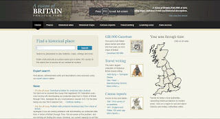
 Narrowing down to the United
Kingdom, A Vision of Britain Through Time is a popular website that links
maps to census reports over the decades.
Select your location of interest and then choose from a range of topics such
as housing, work, and infant mortality, to understand what life was like for
your family at a given period in time.
Also featured is a handy gazetteer from 1900 to help you pinpoint
locations that may have vanished from the landscape since then.
 Many of the place names in
England can be traced back to medieval times, and are listed in Open Domesday, the electronic version of William
the Conqueror’s land survey. Find out who
owned the land, how it was used, what it was worth, and how much tax was
payable on it. If your Latin’s up to
it you can read images of the original book.
Turning finally to the capital
city, Bomb Sight maps the London Blitz of the Second World War, showing the locations where
bombs fell over a nine-month period. You
can see how many bombs were dropped in one night, a week, or overall during
that time. Try exploring a neighbourhood
using the search facility, or for a stunning visual representation of the Blitz,
zoom out of the map using the slider at the left of the screen. Click on a bomb icon to find out its exact site
and description. Some records include
photographs of the aftermath of the bombing and recorded memories of witnesses. If you’re in London, there’s an augmented reality app you can use on the ground.
Geography and history are two strands
of the same thread. It’s almost
impossible to trace your family’s history without being aware of where they
lived or came from. So get digging into
the places of your people’s past, and you’re bound to discover more than just a
spot on the map.

No comments:
Post a Comment